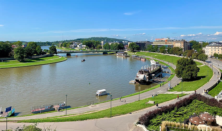
The Vistulan Boulevards are historical hydraulic boulevards used for flood management in Kraków, Poland.
The boulevards are structured from retaining walls (an upper, high, and lower which is used to channel the river channel), allowing the boulevards to perform a river port function.
The 19th- and 20th-century boulevards are used for flood management, namely during the floods of 1970, 1997, and 2010.
The boulevards around the river channel of the Vistula and the Rudawa are part of an area of parkland, being a popular recreational area for Cracovians and tourists alike. The boulevards are pedestrianized, with bicycle routes.
**
Vistula boulevards in Krakow – historic hydro-technical structures with a flood protection function in Krakow along the Vistula, originally also intended for auxiliary functions of port quays.
They mainly consist of retaining walls (upper, high and lower, embracing the river bed and forming a trans-shipment wharf). In the line of the upper walls, there are brick terrain stairs for pedestrians and paved ramps for road communication; railway sidings on the lower level have not survived.
The complex of 19th- and 20th-century boulevards and embankments within Krakow’s borders effectively serves as flood protection, as demonstrated by the experience of great floods, including in 1970, 1997, and 2010.
The boulevards with the adjacent fragments of the Vistula embankments, as well as the Ore Mountains, have re-acquired the function and status of park areas, and are now a popular recreational and leisure destination for Krakow residents and tourists. Walking paths and bicycle paths lead them.
The Vistula boulevards are an object of urban technology on the route of the Krakow Technology Trail established on April 6, 2006. The recreational Vistula Bicycle Route – part of the European EuroVelo 4 bicycle route also runs along them.
In 2009, a water tram was launched in the city, the stops of which are located, among others, at the boulevards: Rodła (“Flisacka”), Czerwienski (“Dębnicki”), Inflancki (“Paulińska”) and Wołyński (“Most Grunwaldzki”).
History
The course of the main Vistula riverbed in the area of the Old Town has been changed many times. Until the thirteenth century, the river flowed along the current bed, but shortly after the city was founded in 1257, in order to bring the river closer to the then-delimited city center, it was decided to build a dam between Skałka and Dębniki. `
The riverbed cut off in this way, fed with the waters of the Wilga River, was called Zakazimierka after the founding of the city of Kazimierz in 1335. The mainstream of the Vistula River was directed to the east behind Wawel.
The Royal Bridge over the Stradom and the railway bridge in Grzegórzki have been thrown over the Vistula that flows there.
This bed, then known as the Old Vistula, was filled in the years 1878–1880. In its place, today’s Dietlów planes and Aleja Daszyńskiego were created (contrary to the name, the Vistula did not flow along today’s Starowiślna Street). This made it possible to regulate the river in its contemporary bed in the years 1905–1909 and to arrange the Vistula boulevards.
The commissioning of the Dąbie Water Barrage in 1961 (as part of the construction of the Upper Vistula Waterway) raised the water table in the center of Krakow, enriching the landscape values of the river and increasing the attractiveness of the boulevards.
In the area of Czerwieński boulevard, in the place of today’s Retoryka Street, the Rudawa River flows into the Vistula. Its bed was filled in in the years 1903–1912, leading it through a ditch to the contemporary estuary in front of the Rodła boulevard.
In 1991, the former names of the Zyblikiewicz, Drobner, and Sakiewicz boulevards were abolished, and divided into districts: Stare Miasto, Zwierzyniec, Podgórze, and Dębniki and giving them new names.
The names of the boulevards (in line with the Vistula River) are as follows:
- on the left bank: the Rodła boulevard, Czerwieński boulevard, Inflancki boulevard, Kurlandia boulevard.
- on the right bank: Tyniecki boulevard, Poleski boulevard, Wołyński boulevard, Podolski boulevard, Lotników Alianckich boulevard.
Left bank of the Vistula River
Rodła boulevard
The boulevard stretches between the mouth of the Rudawa River and the Dębnicki Bridge in the Zwierzyniec district.
There are harbors of sports clubs: AZS-AWF and Nadwiślan.
The boulevard is mostly grassy, gently sloping towards the Vistula River, separated from the upper level of the city by a stylish flood protection wall built in 1905–1909. There is a walking path along the boulevard on the river itself.
Czerwieński Boulevard
It stretches over the bend of the Vistula near Wawel between the Dębnicki and Grunwaldzki bridges in the Old Town district.
There are three monuments by Bronisław Chromy, including the Wawel Dragon and the dog Dżok. Since 2008, it has been the avenue of stars.
A wharf is a mooring place for restaurant barges.
In its place, there used to be the Rybaki district located at the foot of Wawel, where there were breweries and fishermen’s houses. As mentioned in 1644, the Rybaki-Podzamcze jurydyka was abolished in 1801.
A memento of it was the paved Rybaki Street, running on the southwest side of Wawel.
In the 18th and 19th centuries, numerous brick and wooden houses and manors with characteristic Polish broken roofs stood in this area, surrounded by gardens, giving the area a suburban and rural character.
One such mansion stood on the road leading to Skałka by the Vistula River.
These buildings began to disappear in the nineteenth century, due to the beautification works carried out in Krakow, but the last objects of this type, such as the Zieliński manor house (then Rybaki Street No. 4), were demolished only around 1914.
Rybaki Street also ceased to exist, giving a place to future boulevards. The current Rybaki Street runs along Inflancki Boulevard, about a kilometer further down the river, between Hieronima Wietora and Krakowska Streets.
Cyclical and occasional events take place there. Together with Poleski boulevard (located on the opposite side of the Vistula), it is the stage or (depending on the year) of the annual show – Wianki.
This boulevard, cut by numerous walking paths, is mostly a grassy area, gently descending towards the Vistula.
Inflancki Boulevard
It stretches between the Grunwaldzki and Józef Piłsudski bridges in the Old Town district. At this point, on the banks of the Vistula River, there is a church on Skałka.
On the extension of Skawińska Street, there was a wooden Skawiński Bridge, leading towards Skawina and Myślenice. It was burnt down in 1657 by the Swedes leaving the city after the “deluge” (along with other Krakow bridges).
It was replaced by a ferry which was soon closed (due to the low number of users).
The boulevard is mostly grassy and crisscrossed by walking paths. In the northern part, it slopes gently, and in the southern part, the upper and lower part is separated by a stylish wall built in 1905–1909.
In April 2009, a viewing platform suspended by a balloon 150 meters above the ground was launched on Inflanckie Boulevard. It was the first such platform in Poland.
It overlooked both Kazimierz and the Old Town with Wawel, and when the visibility was good, you could even see the Tatra Mountains.
The flights were carried out until January 2010, after which the platform was transferred to the other side of the river (to Volyn boulevard) for a year and a half.
Courland Boulevard
It stretches between the Józef Piłsudski bridges and the railway bridge in Zabłocie in the Old Town district. There is the Powstańców Śląskich bridge next to it. The quay is a berth for barges.
The entire length of the boulevard is divided by a stylish wall, built in 1905–1909, with stairs and descents joining.
Until 1925, there was a Podgórski bridge on this boulevard, connecting it with the Podolski boulevard. This is evidenced by the abutments left on both sides of the river to this day.
Currently, there is the Father Bernatek foot and bicycle footbridge in this place.
Right bank of the Vistula River
Tyniecki Boulevard
It stretches from the area at the beginning of Szwedzka Street to the Dębnicki Bridge, in the Dębniki district. The boulevard is mostly grassy.
Poleski Boulevard
It stretches between the Dębnicki and Grunwaldzki bridges in the Dębniki district. In its vicinity, there is the “Manggha” Museum of Japanese Art and Technology.
Together with the opposite Czerwienski boulevard, this boulevard is, depending on the year, the stage or the auditorium of Wianki.
The boulevard is mostly grassy, gently sloping towards the Vistula, separated from the upper level of the city by a stylish wall built in 1905–1909. Walking paths run along the boulevard.
On this boulevard, as a result of the river accumulation process, the only sandy beach in Krakow is created, which, however, due to water pollution, has no recreational use. The sand at this point is regularly removed from the regulated riverbed by dredgers.
In the area of today’s ul. Zamkowa until the 1940s, the shoreline cut deeper into the river. On the headland that existed at that time, in the years 1891–1938, there was a villa of the Rożnowski family (a building with a characteristic castle appearance).
Volyn Boulevard
It is located between the Grunwaldzki Bridge and the mouth of the Wilga in the Podgórze district. The mouth of the Wilga River forms a picturesque headland, connected by the Retman Bridge with the neighboring Podolski Boulevard.
The characteristic shape of the former Forum Hotel (later Sofitel) is located on Volyn Boulevard.
This boulevard, cut by numerous walking paths, is mostly a grassy area, gently sloping down to the river.
Every year, for several years, at the turn of April and May, a funfair from the Netherlands is stationed in front of the Forum hotel on these boulevards, offering many attractions for children, teenagers, and adults, including “Project 1”, i.e. a huge pendulum, “Extrem” hammer, break dance carousel, autodrome.
In July 2011, a balloon viewing platform from Inflancki Boulevard was moved to this boulevard [note needed].
Podolski Boulevard
It stretches between the mouth of the Wilga River and the Retman Bridge located above it and the railway bridge in Zabłocie in the Podgórze district. There are bridges of Józef Piłsudski and Powstańców Śląskich.
Until 1925, there was a Podgórski bridge on this boulevard, connecting it with the Kurlandia boulevard. This is evidenced by the abutments left on both sides of the river to this day. Currently, there is the Father Bernatek foot and bicycle footbridge in this place.
This is where the salt harbor was located – an important place in the history of Krakow, and earlier, the piedmont industry.
The following buildings are located directly on this boulevard:
Aleksandrowicz’s tenement house – a historic building dominating the panorama of Podgórze seen from the opposite bank of the Vistula
Podgórze power plant – a municipal power plant in the city of Podgórze situated on the route of the Krakow Technology Trail, built in the years 1899–1900.
Currently, the former buildings of the Podgórze power plant are surrounded by the “Cricoteka” (Tadeusz Kantor’s museum complex).
Allied Aviators Boulevard
In 2014, the City Council adopted a resolution to name the Vistula boulevard located on the right bank of the Vistula, between the railway bridge on the cross-city line and the Kotlarski bridge, named after the Allied Aviators.
This was followed by the request of a number of institutions and people promoting the history of aviation – including the Krakow Aviation Senior Club, the Association of Seniors of Military Aviation of the Republic of Poland, the Polish Aviation Museum in Krakow, district councils of III Prądnik Czerwony, XIII Podgórze and XIV Czyżyny and the PODGORZE.PL Association.
In this way, the airmen who delivered weapons and supplies to the fighting Warsaw were commemorated. On the night of August 16-17, 1944, the Consolidated B-24 Liberator plane was damaged by the Germans north of Krakow, shot down over the city, and crashed in Zabłocie near the railway bridge.
The machine was returning from a drop at the “Nida” facility 28 km from Piotrków Trybunalski. Only one aviator survived from the 6-person crew, who jumped out with a parachute in front of Krakow and was saved by Polish partisans.
In the future, a monument commemorating the Allied pilots who died in Małopolska is to be erected on the boulevard. In December 2018, on the boulevard at the end of ul. Przemysłowa, a commemorative stone was erected.
A commemorative plaque is on the wall of the Schindler’s Factory building at ul. Lipowa 4.

